Sunday, June 12, 2011

To The Arctic Circle And Beyond

The North Slope Haul Road was built in 1974 as a supply road for the North Slope oil fields and the Alaska Pipeline construction project. It runs 414 miles north from the end of the Elliot Highway (AK 2) north of Fairbanks and all the way to Prudhoe Bay and the town of Deadhorse. About half of it is paved and half is dirt and gravel.

The pipeline parallels the road for much of its length, allowing plenty of opportunity to marvel at the amount of effort that went into designing and constructing both the road and the pipeline. Both the road and the pipeline cross the Yukon river on a bridge about 55 miles north of the start of the highway at Livingood (rhymes with jive’n good). The river crossing is the first place you can buy gas on the Dalton. The next gas stop isat Coldfoot, 135 miles north of the river. You need to top-up the tank at every available opportunity. The next gas stop would be at the end of the road at Deadhorse, another 230 miles north, but we didn’t go that far. We spent the night in Wiseman, 10 miles north of Coldfoot, and then turned around and rode back to Fox.

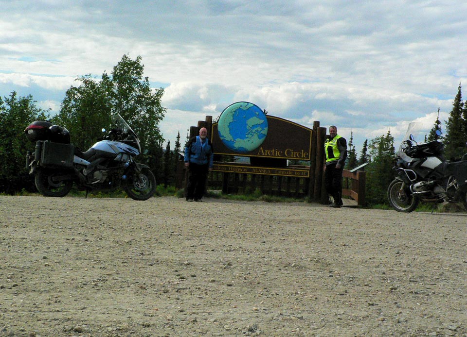
Why ride only half way up the Dalton, or ride any of it for that matter you might ask...because we wanted to say we had ridden to the Arctic Circle would be the answer. The Dalton crosses the Arctic Circle roughly 60 miles north of the Yukon River. It is the only road you can ride to the Arctic Circle and beyond in the US. A motorcycle tour guide we met in Coldfoot put it well…the Haul road is a notch in your belt ride It's not the prettiest or best road to ride in Alaska, but it is a must-do ride. Somewhat less than half the Dalton is paved…some good, some not so good. The rest is dirt and gravel…some good, some not so good. And when it rained, the dirt sections were pretty slick. On some sections we could run 65 mph, and on some it was more like 35.

The shot below shows the smoke from several forest fires near the start of the road. Smoke was pretty heavy in the air for awhile, until we got beyond the fires. On our return trip, the fires had moved south, much closer to Fox where we were staying…the closest being about 15 miles from the B&B.

This is the approach to the Yukon River crossing.


This bridge conveys both vehicles and the pipeline across the river.

We reach our principal goal, the Arctic Circle, about 2 in the afternoon, latitude 66 deg 33’ 44” .


I had to add a shot to my peeing across America series…probably the most significant pee shot yet.

We spent the night at The Arboreal Lodge in Wiseman, population 15 according to the lodge owner (the 21 population figure I mentioned in the previous post was from the 2000 census).

Main Street Wiseman.


Wiseman is situated directly on the Koyukuk River, and was founded in 1919 as a gold mining and trading settlement.


The Wiseman Post Office closed in 1956.


You can’t buy a meal in Wiseman, so we ventured back down the road to Coldfoot for Dinner at Coldfoot Camp. Coldfoot Camp is one of the camps that sprang up during construction of the pipeline to house and feed the workers. They serve an excellent buffet every night with a wide variety of tasty dishes.

Wednesday morning we rode a few miles further north on the Dalton from Wiseman to the base of the Brooks Range, the northernmost mountain range in the US. As you can see, this 23 mile stretch of the Dalton was recently paved and is as good as any highway we have been on. It is strange how certain seemingly random stretches have been paved with the rest left natural.


We then turned around and headed back to Coldfoot for gas, and continued on back down to the Yukon River for gas and lunch, and then back to the Fox Creek B&B for the night, passing through some serious fire areas just 15 miles north of Fox.

Tuesday, June 7, 2011

It's A Wild Life (Bonanza)

The last time you heard from Snake and Inspector G we were in Bemidji last Tuesday night. Wednesday we entered Canada south of Winnipeg and headed west on Canada 1 through Ragina (rhymes with Vagina…I’ve been waiting all week to say that) and Highway 11 to Craik where we spent the night at the C&T Motel which we dubbed the Bates Motel. Craik is a tiny town with mostly dirt streets and one motel, straight out of Alfred Hitchcock’s Psycho. The few towns-people we met could have been extras from the movie.

Thursday we picked up Canada 16 and pushed on through Saskatoon and Edmonton, then Canada 43, stopping in Whitecourt at the Howard Johnson’s for the night where we conversed to the wee hours with some local oil and gas field workers about how Canada could supply all of our energy needs if we would just let them.

Friday dawned cold and rainy which quickly transitioned to colder and snowy. After about an hour we pulled into a rest area to thaw out. It took way too long to thaw our hands under the warm air dryers and running water. Our fingers had to be very close to frost bite and us to hypothermia.


We pushed on through the snow and rain through Grand Prairie to Dawson Creek, BC, the start of the Alcan Highway and a major milestone on this trip.


We rode as long as we could and finally stopped for the night at the Bucking Horse River Lodge (read truck stop) near Pink Mountain, about 120 mi short of our preplanned destination of Fort Nelson. After canceling three nights reservations in a row and trying to make up miles and taking potluck where we could, we finally caught up to our schedule in Watson Lake, Yukon Saturday night, the home of the World-famous Sign Post Forest. I brought a front license plate from Bat Cave, NC with me to nail up in the “Forest”. I had wanted to put up a “Lake Lure – Gem Of The Carolinas” plate, but nobody in Lake Lure, including the Visitor Center and the Chamber of Commerce, could tell me where to get one. The fruit stand in Bat Cave, however, had plenty of Bat Cave plates. It's much cooler than the Lake Lure sign anyway.


The ride from Pink Mountain to Watson Lake was a wildlife bonanza. We saw bears, buffalo (Woods Bison), moose, an elk, and an eagle.


We entered Alaska on the Alcan Highway around 2 pm Monday 6/6, another trip milestone,
and arrived at the Fox Creek B&B in Fox, just north of Fairbanks around 7 pm. Supper was at The Silver Gulch Brewery that was featured on Diners, Drive-Ins, and Dives last year.


Tomorrow we are off to ride the Haul Road, aka the Dalton Highway, north to the Arctic Circle, where we plan to spend the night in Wiseman, population 21. I'm pretty sure there will be no internet in Wiseman. We will be back here at the Fox Creek B&B on Wednesday night where Jeff and Arna are our lovely hosts. Jeff is a media specialist at U of Alaska so internet access is assured.

Tuesday, May 31, 2011

North To Alaska

I'm David. My daughter-in-law Kristen's father is David. Her Step-father is David, and her brother is David. We were all together in Cary, NC for grand daughter Rachel's fifth birthday party on Saturday. Whenever somebody said "Dave?", four guys turned and said "yes?"

Sunday breakfast was a kind of bon voyage party for me and Kristen's father David's trip to Alaska. We both rode to Cary for the birthday party so we could leave from there to begin our Alaska adventure. It has been one year in the planning from the time last May when Dave W and I were helping to babysit grand daughter Rachel at her home in Cary. When I told Dave W that I was planning on riding to Alaska in 2011, I could tell from the look in his eyes that he would like to go. And so began the planning, culminating in yesterday's departure from Cary with an over-night stop at Dave W's home in Louisville. That's about 550 miles for day zero. I consider Monday to be day one since we left Dave W's home with Alaska as the destination.

OK, we need some nicknames here....there are too many Dave's. So, for the purposes of this ride report, Dave W will be Inspector Gadget, or just Gadget for short, and I will be Mr. Snakester, or Snake for short. We both had eventful rides to Cary on Friday. It rained most of the way for both of us. Here's a photo of the start of my trip.


I didn't make it out of the driveway before dropping the V-Strom on it's side. Gadget managed to make it to Cary without dropping his GS 1200, but he had to ride through 9 hours of rain and fog to get there. Here are Gadget and Mrs Gadget with Snake and Mrs Snake (the original Snakester) at the hotel Sunday morning.


Saying goodbye to Rachel after breakfast at Mimi's Grille and getting ready to hit the road.


Day Zero, 6/29: Cary to Louisville where Gadget lives, 555 mi. Hot and Sunny. Nice ride. I'm calling it day zero because Gadget ended up back where he started from on Friday.

Day one, 6/30: Louisville to Waterloo, Iowa, 560 mi. Hot and sunny and extremely windy, but not as windy as day two.

Day two, 6/31: Waterloo to Bemidji, MN, 444 mi. Cold and rainy with maniacal winds. This was the ride from hell. We were supposed to be in Kenmare, ND tonight, but conditions did not allow. It was unsafe to stay on interstate 94 west out of Minneapolis due to the wild and crazy wind that made it difficult to stay in a lane, let alone remain up-right. Add to this that Minot, ND (on our I-94 route to Kenmare) was flooding and being evacuated, and we had to bail on the original plan. So we reevaluated our route and headed north on Highway 71 and ended up in Bemidji, where wind conditions were continuing to worsen. This throws our entire schedule, and all lodging reservations, into chaos. Weather tomorrow is supposed to improve, and we hope to put in a long day and cover beau coup miles and get back on schedule by Friday so we don't have to cancel all remaining reservations. Best laid plans often go awry, but I wouldn't have guessed that it would be due to wind, oh yeah, and flooding. Stay tuned.

Monday, October 18, 2010

A Triple-D Dive

This bike trip was supposed to be a National Park and Triple-D Tour...Triple-D referring to Diners, Drive-Ins, and Dives -- Guy Fieri's popular Food Network show. I had my list of Triple-D establishments with me on the trip, hoping to stop at several of the restaurants along the way. As things turned out, I managed to visit only one place on the list and that was for lunch on the next-to-the-last day on the road. Welcome to Cozy Corner in Memphis, TN!

Cozy Corner definitely qualifies as a Dive, as testified to by the decor, including the duct tape patches you will find on most of the booth seats. But it is a long-lived and beloved dive. Located at 745 N Parkway just north of I-40 and half a block east of Thomas St (Rte 51) Cozy Corner has been serving up barbecue to Memphis folks for over 30 years. I recognized photos of Danny DeVito and a host of other movie stars, politicians, and dignitaries tacked on the bulletin boards. People who love barbecue don't come here for the decor, they come for the food. Raymond Robinson began cooking ribs and shoulders at this unassuming location a long time ago. Raymond is no longer with us, but his widow, Desiree, carries on the tradition. It was Desiree who was featured in the Triple-D episode on Memphis barbecue when Guy visited Cozy Corner two years ago, and it was Desiree who greeted us at the entrance when we walked in. Guy always concentrates on a couple of specials of the house at each place he visits on the show. I asked Desiree what dish Guy featured at Cozy Corner because it had been quite awhile since I had seen the show and I couldn't remember the details. As soon as she said Cornish Hen, it all came back to me. They do Cornish Hens the same way they do their ribs and shoulders, using the same dry rub and low-and-slow smoking method. I had to try it, and it was great. Ron ordered the ribs and wings combination, and pronounced it very tasty. My only complaint would be having to try and eat a Cornish Hen using a plastic fork and knife. I quickly gave up on that and just tore it apart and ate with my fingers...the way barbecue is supposed to be eaten. I was too anxious to dive in to the food to think about taking photos before we dug in, so what you see here are pretty much the remnants.

That's Desiree in the white cap and jacket behind the counter and also her picture on the banner.

By the time we finished eating, there were only two other customers in the restaurant...a couple from Tulsa who were on their own Triple-D/barbecue tour. He had his own list of Triple-D establishments, but he said they were at Cozy Corner because of the write-up in the BBQ magazine that you see in his hand. He had missed the Triple-D episode that featured Cozy Corner, but a glowing review in the magazine enticed them to seek it out. They not only ate lunch, but also carried out a large bag of to-go ribs and pulled pork. I'm guessing that is Desiree's grandson standing beside her. I forgot to ask, but it is definitely a family affair.

Since we only managed to eat at one Triple-D establishment on this ride, I'm glad it turned out to be Cozy Corner and that we got to experience a Memphis institution and meet Desiree Robinson.

Trip Pics

Here are some photos from the trip without a whole lot of boring words.

UT 95 north of Glen Canyon.

UT 12 South of Torrey, UT with the aspen trees in full glory.

Bryce Canyon National Park Hoodoos (rock spires).
Inspiration Point in Bryce Canyon.
Jim on a rock on the North Rim of the Grand Canyon.
Ron on a rock on the North Rim of the Grand Canyon.

Jim and David on the rocks on the North Rim of the Grand Canyon.

Jim, Ron, David, and Fehmi in Oak Creek Canyon just east of Sonoma, AZ. We met Fehmi the night before at the Best Western in Flagstaff. Fehmi is from Turkey and was riding from Chicago to LA following Rte 66 all by himself on a rented Harley. He spent Tuesday Oct 5 riding with us through Oak Creek Canyon, Sonoma, Jerome, and Prescott. It rained a lot that day. Here's a link to a video of Fehmi riding through Jerome. Jerome is a historic copper mining town perched on the side of a mountain west of Cottonwood. According to Wikipedia: "Jerome became a notorious "wild west" town, a hotbed of prostitution, gambling, and vice. On 5 February 1903, the New York Sun proclaimed Jerome to be "the wickedest town in the West"."

Along AZ 89 north of Flagstaff.

UT 261 -- The Moki Dugway

I've been back home from our out-west bike trip for over a week now. I didn't get to do nearly as many posts from the road as I had planned to do because of time and internet constraints, so I'm going to try and catch up on a couple of posts that I should have done from the road.

Utah Highway 261 north of Mexican Hat (home of the swinging steak as seen on Alton Brown's Feasting On Asphalt) is probably the most interesting and challenging road we encountered on this trip...at least the section known as the Moki (or Mokee, or Moqui) Dugway. The MD is a three-mile stretch of UT 261 that climbs the face of Cedar Mesa. It is unpaved, steep, and narrow, with very sharp hair-pin switchbacks, steep drop-offs and no guardrails.

On our way from Durango, CO to Torrey, UT on this particular day, we had stopped at the San Juan Motel, perched on the north bank of the San Juan River in Mexican Hat, for some liquid refreshment for old-times sake since we had stopped at this same establishment on a previous trip several years ago. On that previous trip, the temp was 106 F and the gas boiled out our tanks onto the pavement while we were inside in the swamp-cooled air. On this day, it was only about 90 F and much more comfortable.


Upon leaving the San Juan, we headed north on UT 163 and took the first left on UT 261 which runs north to UT 95 and Natural Bridges National Monument. We weren't really prepared for what lay ahead....the Moki Dugway. When we saw the sign above, we knew we were in for a challenge, since none of our bikes would be considered off-road worthy. On my AAA Utah state map, the road appeared straight and 100 percent paved. If I had had access to Google Maps, I could have seen the following two representations of that section of 261.


One approaches Cedar Mesa from the south gazing at what appears to be a shear rock wall and wondering "So where does the road go?" As you get closer, you discover the answer is "Up the face of the cliff." To add insult to injury, they have left this section of the highway unpaved and covered in loose gravel. To the state's credit, they have paved a few feet in each of the hairpin switchbacks to make it easier to negotiate those tricky sections.


We pulled over at the bottom of the mesa where the road transitions from asphalt to gravel to psych ourselves up for the ascent and then proceeded the three miles to the top without incident. Once on top, the road is again paved and relatively straight.


Roads like this are what memorable rides are made of. For obvious reasons, I didn't shoot any video while negotiating the Moki Dugway, but here is a link to a You Tube video that someone shot from a truck while driving down the Dugway from the top to the bottom.