Tuesday, June 21, 2011

Fish Are Jumping And The Cotton Is Nigh

We left Homer on Wednesday morning 6/15 in a cold rain with Seward as our destination for the night. We reached Seward at 4 in the afternoon, thoroughly wet and chilled to the bone. It made us appreciate all the more our warm and cozy rooms at the Bears Den B&B with radiant floor heating. After Dinner at Chanooks, with a beautiful view of the harbor and the mountains beyond, we turned in early and awoke to a fairly sunny day.

Dave snapped this eagle sitting on the pier, looking straight at him as if to say, “are you looking at me?”

On the way out of town, we took a short side trip to visit Exit Glacier, one of many we would see over the next several days. Penny wants you to know that it is her riding clothes that make her look like the Michelin Man, not all of the food we have been consuming.

A little further up the road, another turn-off onto Bear Lake road took us a short distance to the Bear Lake Fish Weir and salmon tagging and rehab project run by the Cook Inlet Aquaculture Association. Salmon were lined up far downstream waiting their turn to try and jump and swim up the weir.

Ordinarily, they would be trapped by the hundreds, and the females would be tagged and treated for the virus they are infected with, and then released. Unfortunately, on this day, the hoist on the weir trap was broken, and and few fish were getting through. They were backing up in the stream for hundreds of yards, if not for miles.

The young man standing next to Tulin, probably about 14 or 15 years old, is a summer intern on the project. He was very knowledgeable about the life-cycle of salmon and gave us quite an education in salmon and the work they are doing at the weir.

Here he is attempting to catch a salmon with his bare hands.

Just south of Girdwood is the turnoff to Portage Glacier Recreational Area. You can hike out to the glacier if you are feeling ambitious, or you can do like we did and view it from a distance, across Portage Lake.

The girls were like two sure-footed mountain goats traversing the large rocks at the edge of the lake.
That’s a big chunk of ice from the glacier floating in the lake.

We arrived back at the House of Jade B&B around 6 pm and went out to celebrate our 45th anniversary two days early since the guys and girls were splitting up for three days, and Penny and I would not be together on the 18th. Our original plan called for all four of us to ride from Anchorage to Haines to catch the ferry to Juneau and on down to Prince Rupert, BC. But, after our experience riding the Alcan Highway between Haines Junction and the Alaska border on our way up, we changed the plan and decided to fly the girls to Juneau instead of subjecting them to riding that very rough stretch of road.

After dinner at Simon and Seafort's, we drove around Anchorage for awhile including a drive to the top of Flat-Top Mountain for a view of the city from on-high and this view of Mt. McKinley at about 11:30 pm from 150 miles away.

Parting is such sweet sorrow. The girls were sad to see us depart the House of Jade on the 17th to begin our ride to Haines to catch the ferry on the 19th. We would be reunited in Juneau on Sunday the 19th, and would all get on the ferry for the three-day trip down the Inside Passage to Prince Rupert.

Tuesday, June 14, 2011

The Girls Are Coming, The Girls Are Coming


Actually, the girls are already here and have been since last Thursday night, having flown into Anchorage about 10 pm. The B&B we were staying at, The Alaska House Of Jade, loaned us a van to drive to the airport and pick them up so we wouldn't have to do it on the bikes. The next day we spent driving around Anchorage in the van doing laundry, having lunch at Snow City Cafe, and shopping for wine at Cosco. The girls didn't have to get on the bikes until Saturday morning to head up the road to Talkeetna. They were totally spoiled by then, and would have been happy to keep the van for the entire trip. Our hosts Dee and Yves at the House Of Jade really set the standard for lodging on this trip. Dee whips up amazing breakfasts. Penny has already posted some of her recipes on her food blog.

We decided we didn't have to worry about carying emergency fuel for the remainder of the trip, so we ditched the spare fuel bottles and replaced them with wine. It's like the fuel holders were designed with wine in mind.

We rode up to Talkeetna on Saturday. It was Tulin's first real experience of riding for an extended period...until then, she had only ridden for an hour or so. She did great, and is really enjoying herself. Penny is a pretty old-hand at this stuff and is having a good time.


We stayed at the Meandering Moose B&B in Talkeetna.

They say Talkeetna was the model for the town in Northern Exposure even though the series wasn't filmed there. This is Main Street Talkeetna.


After dinner at the West Rib, we rode over to the Talkeetna Lodge in hopes of getting a glimpse of Mt. McKinley. The Lodge has a nice terrace facing Denali Park and offering good views of the mountains. It's about 10:30 pm in this shot, but see how bright the sun is.

The distant mountains, which include McKinley, were shrouded in clouds when we arrived, but after a half hour or so the clouds began to thin and we were treated to this view of McKinley sticking up above the clouds.

McKinley, which the Indians called Denali, meaning "the high one", is the highest peak in North America at 20,320 ft compared to Everest at 29,029 ft. However, Denali has a greater vertical rise from its base to its peak than does Everest...18,000 ft versus 12,000 ft, making it both challenging and popular with climbers. A world-class German climber, Dr. Olaf Rieck, was staying at the Meandering Moose with us. He had just led an expedition of 13 international climbers to the peak of Denali. This interesting veterinarian has climbed all over the world, including Mt. Everest. Here he is showing me his website which is in German, but interesting nonetheless.


I asked Tulin to take a photo at midnight to show the amount of light still available...here it is. We find it hard to go to bed and to sleep at a normal hour with so much daylight.


From Talkeetna, we traveled southward back through Anchorage and on down the Kenai Peninsula to Homer, the Halibut capitol of the World. The Cook Inlet was on our right a good part of the way.
This is a small part of the harbor at Homer.


Inspector G and I had to try halibut fishing. We went out on the charter boat "Wild Thing" with Captain Mike. This is the hook that is used to fish for halibut.

The hook is rigged with a 2 lb sinker, baited with herring, and fished on the bottom in about 150 ft of water. It's a major work-out just to check your bait, let alone to haul in a fish.


The current limit is two fish per person. The day before, one of Capt. Mike's customers landed a 90 pounder. Today, the best we could do was the 25 pounder caught by Gadget. The rest of the fish we kept were in the 18-22 lb range. That's Capt. Mike in orange putting a fish in the box.


Along with Gadget and me on the boat were two couples from Carson City, NV. Here we all are with the day's catch.


I'm sad to say this fish, tipping the scales at 165, was caught by someone else. To keep us from feeling quite so bad, they tried to tell us that fish this large don't taste as good as the smaller ones.

The Salty Dog is an iconic bar on the Homer "spit". It sits right at the entrance to the charter boat dock and is a required stop at the end of a day of fishing.

The interior is decorated with a few more signed dollars than Larkin's Bayfront Tavern in Lake Lure.

We added our bill to the collection. It's right there between Tulin and Penny, just above their heads.


Here's a closeup. Not to be outdone, we used a 1000 won note from Korea, worth all of about 98 cents.

We finished the day with a visit to Lands End Restaurant at the very tip end of the "spit" for a drink and a late lunch of French onion soup and seafood chowder.

Lands End sits right at the entrance to Kachemak Bay. This was shot right behind the restaurant.

Tomorrow (Wed 6/15) we are on the road again, back up the Kenai Peninsula to Seward for the night. Then on Thursday we return to Anchorage for one night and on Friday we put the girls back on an airplane to Juneau while we ride to Haines and catch the ferry to Juneau. This is a change in plans caused by the terrible condition of the Alcan Highway south of the Alaska border down to Haines Junction, Yukon Territory. On the way up, after encountering this section of highway, we decided it was too rough to ride two-up with the girls. We plan to rendezvous with them in Juneau on June 19 and continue with the ferry on down to Vancouver Island.

Sunday, June 12, 2011

To The Arctic Circle And Beyond

The North Slope Haul Road was built in 1974 as a supply road for the North Slope oil fields and the Alaska Pipeline construction project. It runs 414 miles north from the end of the Elliot Highway (AK 2) north of Fairbanks and all the way to Prudhoe Bay and the town of Deadhorse. About half of it is paved and half is dirt and gravel.

The pipeline parallels the road for much of its length, allowing plenty of opportunity to marvel at the amount of effort that went into designing and constructing both the road and the pipeline. Both the road and the pipeline cross the Yukon river on a bridge about 55 miles north of the start of the highway at Livingood (rhymes with jive’n good). The river crossing is the first place you can buy gas on the Dalton. The next gas stop isat Coldfoot, 135 miles north of the river. You need to top-up the tank at every available opportunity. The next gas stop would be at the end of the road at Deadhorse, another 230 miles north, but we didn’t go that far. We spent the night in Wiseman, 10 miles north of Coldfoot, and then turned around and rode back to Fox.

Why ride only half way up the Dalton, or ride any of it for that matter you might ask...because we wanted to say we had ridden to the Arctic Circle would be the answer. The Dalton crosses the Arctic Circle roughly 60 miles north of the Yukon River. It is the only road you can ride to the Arctic Circle and beyond in the US. A motorcycle tour guide we met in Coldfoot put it well…the Haul road is a notch in your belt ride It's not the prettiest or best road to ride in Alaska, but it is a must-do ride. Somewhat less than half the Dalton is paved…some good, some not so good. The rest is dirt and gravel…some good, some not so good. And when it rained, the dirt sections were pretty slick. On some sections we could run 65 mph, and on some it was more like 35.

The shot below shows the smoke from several forest fires near the start of the road. Smoke was pretty heavy in the air for awhile, until we got beyond the fires. On our return trip, the fires had moved south, much closer to Fox where we were staying…the closest being about 15 miles from the B&B.

This is the approach to the Yukon River crossing.


This bridge conveys both vehicles and the pipeline across the river.

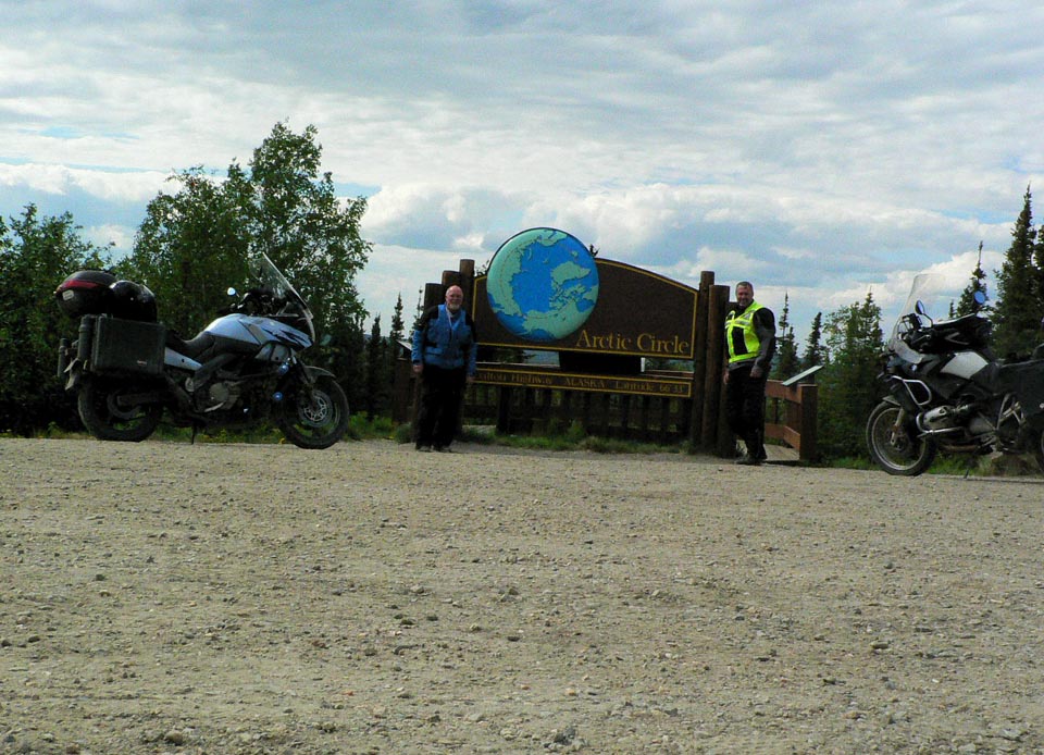
We reach our principal goal, the Arctic Circle, about 2 in the afternoon, latitude 66 deg 33’ 44” .


I had to add a shot to my peeing across America series…probably the most significant pee shot yet.

We spent the night at The Arboreal Lodge in Wiseman, population 15 according to the lodge owner (the 21 population figure I mentioned in the previous post was from the 2000 census).

Main Street Wiseman.


Wiseman is situated directly on the Koyukuk River, and was founded in 1919 as a gold mining and trading settlement.


The Wiseman Post Office closed in 1956.


You can’t buy a meal in Wiseman, so we ventured back down the road to Coldfoot for Dinner at Coldfoot Camp. Coldfoot Camp is one of the camps that sprang up during construction of the pipeline to house and feed the workers. They serve an excellent buffet every night with a wide variety of tasty dishes.

Wednesday morning we rode a few miles further north on the Dalton from Wiseman to the base of the Brooks Range, the northernmost mountain range in the US. As you can see, this 23 mile stretch of the Dalton was recently paved and is as good as any highway we have been on. It is strange how certain seemingly random stretches have been paved with the rest left natural.


We then turned around and headed back to Coldfoot for gas, and continued on back down to the Yukon River for gas and lunch, and then back to the Fox Creek B&B for the night, passing through some serious fire areas just 15 miles north of Fox.